Daha Büyük Görüntüle
Adıyaman
Location of Adıyaman within Turkey.
Adıyaman is located in Turkey
Adıyaman
Location of Adıyaman within Turkey.
Coordinates: 37°45.85′N 38°16.57′ECoordinates: 37°45.85′N 38°16.57′E
Country Turkey
Region Southeastern Anatolia
Province Adıyaman
Government
• Mayor Muhammet Necip Büyükaslan (AKP)
• Governor Ramazan Sodan
Area
• Total 1,582 km2 (611 sq mi)
Elevation 7 m (23 ft)
Time zone EET (UTC+2)
• Summer (DST) EEST (UTC+3)
Postal code 02xxx
Licence plate 02
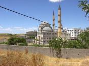
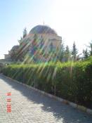
Adıyaman (Kurdish: Semsűr, The ancient Perre or Pordonnium, Ancient Greek: Περρη) is a city in southeastern Turkey, capital of the Adıyaman Province. It is one of the fastest-growing cities in Turkey. The population rose from 100,045 (1990) to 202,735 [1] (2010 census figures).
Contents
1 Etymology
2 Climate
3 History
4 Adıyaman today
5 Places of interest
6 Notalbe Residents
7 See also
8 References
Etymology
The city officially had the name Hısn-ı Mansur ("Castle of Mansur") until the year 1926, named after the fortified castle perched on a hill around which the city grew. As this name was difficult for the locals to pronounce, people were referring the city as adı yaman, which means "its name is tough" or "(the place) whose name is tough" in Turkish.[citation needed] In 1926, this term was adopted as the official name of the city. In present-day Turkish, the word yaman can also have a strong positive connotation, just like the English word 'terrific'.
Climate
Adıyaman has a semi-arid climate. Summers are very hot and very dry. Temperatures reach 40 °C (104.0 °F) at the height of summer for the majority of the time. The highest recorded temperature was 45.3 °C (113.5 °F) on 30 July 2000. Winters in Adıyaman are cool/cold and quite often snowy. The lowest recorded temperature was −10 °C (14.0 °F) on 23 February 1985.
History
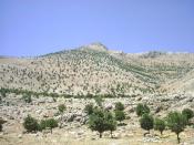
The area has been inhabited as far back as it's possible to discover. Research in the cave of Palanlı 10 km north of Adıyaman show occupation in 40,000 BC and other digs in Samsat reveal continuous occupation through the stone and Bronze Ages.
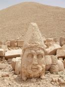
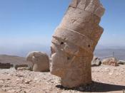
From 900BC onwards came waves of invasions from Assyrians, Persians, and Macedonians until the Commagene kingdom was founded in 69BC. This was the civilisation that built the statues on top of nearby Mount Nemrut. The capital was in Samsat (Samosata) but the town of Adıyaman was a walled city of the Commagenes. The city walls of Adıyaman have been restored and replaced many times since.
The Commagene kingdom lasted until the Romans came in 72AD. Yet more campaigns and invasions followed and Adıyaman was controlled by Byzantines 395-670, Ummayads from 670 and then Abbasids 758-926. Then the area returned to Byzantine control during 859-1114. The Arabs returned from 1114 to 1204 and finally came the arrival of the Turks. The Arabic name for the castle and town was Hısn-ı Mansur[citation needed].
Turks moved into the area from 1114 onwards and for most of the 13th century was settled by the Selçuk Turks often disrupted by Mongol invasions. From 1298 to 1516 the town was under the control of the Mameluks. Adıyaman was brought into the Ottoman Empire by Selim I in 1516, but local power often rested with the Dulkadiroğulları tribe of Türkmen people that settled here[citation needed].
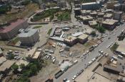
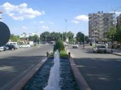
Adıyaman today
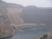
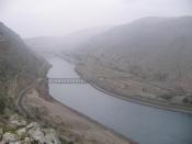
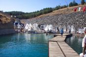
The city of Adıyaman provides shops and infrastructure to an agricultural region watered by the River Euphrates. It is not an industrial city, people riding mules and donkeys are still a common sight. The Atatürk reservoir is near the city and with more investment in irrigation, this could become a richer agricultural zone. The people are religious and conservative; it is hard to find a beer in Adıyaman, or other social amenities like cafes, cinemas, and theatre. The cuisine is typical of south-east Turkey, including dishes like çiğ köfte and Maraş-style ice-cream.
Adıyamanspor is a minor league football team.
Places of interest
There is some passing tourist trade, the main tourist attraction being Mount Nemrut.
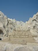
The caves of Pirin (ancient city of Perre) are 5 km (3 mi). from Adiyaman. These have been used as a burial ground for thousands of years. The sights include the ruins of the city and burial caves carved into the rock.
Further tourist information is available at the Southeastern Anatolian Promotion Project site.
The ancient city of Arsemia, the summer retreat of the Kingdom of Commagene, can also be visited.
Source |