Daha Büyük Görüntüle
Izmir
İzmir
— City —
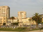
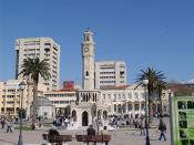
Konak Square in central Izmir
Nickname(s): Pearl of the Aegean
Izmir is located in Turkey
Izmir
Location of Izmir
Coordinates: 38°26′N 27°09′E
Country Turkey
Region Aegean Region
Province İzmir Province
Government
• Mayor Aziz Kocaoğlu
(CHP)
Elevation 2 m (7 ft)
Population (2011)[1][2]
• City 2,783,866
• Metro 3,366,947
Time zone EET (UTC+2)
• Summer (DST) EEST (UTC+3)
Postal code 35xxx
Area code(s) (+90) 232
Licence plate 35
Izmir (Turkish: İzmir; Greek: Σμύρνη Smyrni; Latin: Smyrna) is a large metropolis in the western extremity of Anatolia and the third most populous city in Turkey. Izmir metropolitan area extends along the outlying waters of the Gulf of İzmir and inland to the north across Gediz River's delta, to the east along an alluvial plain created by several small streams and to a slightly more rugged terrain in the south. The ancient city was known as Smyrna, and the city was generally referred to as Smyrna in English, until the Turkish Postal Services Law of 1930 made "Izmir" the internationally recognized name.
The city of Izmir is composed of several metropolitan districts. Of these, Konak district corresponds to historical Izmir, this district's area having constituted the "Izmir Municipality" (Turkish: İzmir Belediyesi) area until 1984, Konak until then having been a name for a central neighborhood around Konak Square, still the core of the city. With the constitution of the "Greater Izmir Metropolitan Municipality" (Turkish: İzmir Büyükşehir Belediyesi), the city of Izmir became a compound bringing together initially nine, and since recently eleven metropolitan districts, namely Balçova, Bayraklı, Bornova, Buca, Çiğli, Gaziemir, Güzelbahçe, Karabağlar, Karşıyaka, Konak and Narlıdere. Almost each of these settlements are former district centers or neighborhoods which stood on their own and with their own distinct features and temperament. In an ongoing processus, the Mayor of Izmir was also vested with authority over the areas of additional districts reaching from Aliağa in the north to Selçuk in the south, bringing the number of districts to be considered as being part of Izmir to twenty-one under the new arrangements, two of these having been administratively included in Izmir only partially.
According to the Turkish Statistical Institute, as of 2011 the city of Izmir had a population of 2,783,866 and its metropolitan municipality 3,366,947.
Main features
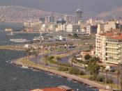
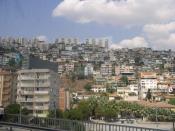
Astronaut photograph highlighting the modern urban landscape of İzmir.
İzmir has almost 3,500 years of recorded urban history (see Timeline of İzmir) and possibly even longer as an advanced human settlement. Lying on an advantageous location at the head of a gulf running down in a deep indentation midway on the western Anatolian coast, the city has been one of the principal mercantile cities of the Mediterranean Sea for much of its history. Its port is Turkey's primary port for exports in terms of the freight handled and its free zone, a Turkish-U.S. joint-venture established in 1990, is the leader among the twenty in Turkey. Its workforce, and particularly its rising class of young professionals, concentrated either in the city or in its immediate vicinity (such as in Manisa and Turgutlu), and under either larger companies or SMEs, affirm their name in an increasingly wider global scale and intensity.[3] İzmir is widely regarded as one of the most progressive Turkish cities in terms of its values, lifestyle, dynamism and gender roles. Politically, it is considered a stronghold of the Republican People's Party.
The city hosts an international arts festival during June and July, and the İzmir International Fair, one of the city's many fair and exhibition events centered around but not limited to Kültürpark, is held in the beginning of September every year. İzmir is served by national and international flights through the Adnan Menderes International Airport and there is a modern metro line running from the southwest to the northeast. İzmir hosted the Mediterranean Games in 1971 and the World University Games (Universiade) in 2005. It had a running bid submitted to the BIE to host the Universal Expo 2015, in March, 2008, that was lost to Milan. Modern İzmir also incorporates the nearby ancient cities of Ephesus, Pergamon, Sardis and Klazomenai, and centers of international tourism such as Kuşadası, Çeşme, Mordoğan and Foça.
Despite its heritage, İzmir has suffered until recently, as one author puts it, from "sketchy understanding" in the eyes of outsiders. When the Ottomans took over İzmir in the 15th century, they did not inherit compelling historical memories, unlike the two other keys of the trade network, namely Istanbul and Aleppo. Its emergence as a major international port as of the 17th century was largely a result of the attraction it exercised over foreigners, and the city's European orientation.[4] Very different people found İzmir attractive over the ages and the city has always been governed by fresh inspirations which stemmed from the location of its center and the readiness of its citizens to adopt novelties and new projects.
Names and etymology
İzmir is a princess with her most beautiful hat.
Victor Hugo[5]
The modern name "İzmir" derives from the former Greek name Σμύρνη "Smyrna", through the first two syllables of the phrase "εις Σμύρνην" (pronounced "is Smirnin"), which means "to Smyrna" in Greek. A similar etymology also applies for other Turkish cities with former Greek names, such as İznik (from the phrase "is Nikaean", meaning "to Nicaea"), Istanbul (from the phrase "is tan Polin" or "to the City") or even for the Greek island of Kos, called "İstanköy" in Turkish.
In ancient Anatolia, the name of a locality called Ti-smurna is mentioned in some of the Level II tablets from the Assyrian colony in Kültepe (first half of the 2nd millennium BC), with the prefix ti- identifying a proper name, although it is not established with certainty that this name refers to modern day İzmir.[6]
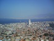
A view of central Izmir
The region of İzmir was situated on the southern fringes of the "Yortan culture" in Anatolia's prehistory, the knowledge of which is almost entirely drawn from its cemeteries,[7] and in the second half of the 2nd millennium BC, in the western end of the extension of the yet largely obscure Arzawa Kingdom, an offshoot and usually a dependency of the Hittites, who themselves spread their direct rule as far as the coast during their Great Kingdom. That the realm of the 13th century BC local Luwian ruler who is depicted in Kemalpaşa Karabel rock carving at a distance of only 50 km (31 mi) from İzmir was called the Kingdom of Myra may also leave ground for association with the city's name.[8]
The newest rendering in Greek of the city's name we know is the Aeolic Greek Μύρρα Mýrrha, corresponding to the later Ionian and Attic Σμύρνα (Smýrna) or Σμύρνη (Smýrnē), both presumably descendants of a Proto-Greek form *Smúrnā. Some would see in the city's name a reference to the name of an Amazon called Smyrna who would have seduced Theseus, leading him to name the city in her honor.[9] Others link the name to the Myrrha commifera shrub, a plant that produces the aromatic resin called myrrh and is indigenous to the Middle East and northeastern Africa. The Romans took this name over as Smyrna which is the name that is still used in English when referring to the city in pre-Turkish periods.
As shown above, the name İzmir (Ottoman Turkish: إزمير İzmir) is the modern Turkish version of the name Smyrna/ Smyrni. In Greek it is Σμύρνη (Smýrni), Իզմիր (Izmir) in Armenian, Smirne in Italian, Esmirna in Spanish, Smyrne in French, and Izmir (without the Turkish dotted İ) in Ladino.
In English, the city was called Smyrna until the Turkish Postal Service Law of 28 March 1930, upon which the name Izmir (sometimes İzmir) was also adopted in English and most foreign languages.[10]
İzmir panorama from Kadifekale.
History
See also: Timeline of Izmir
Ancient age
Main article: Smyrna
The city is one of the oldest settlements of the Mediterranean basin. The 2004 discovery of Yeşilova Höyük and the neighboring Yassıtepe, situated in the small delta of Meles River, now the plain of Bornova, reset the starting date of the city's past further back than was previously thought. The findings of the two seasons of excavations carried out in the Yeşilova Höyük by a team of archaeologists from Izmir's Ege University indicate three levels, two of which are prehistoric. Level 2 bears traces of early to mid-Chalcolithic, and Level 3 of Neolithic settlements. These two levels would have been inhabited by the indigenous peoples of the area, very roughly, between 7th millennium BC to 4th millennium BC. With the seashore drawing away in time, the site was later used as a cemetery. Several graves containing artifacts dating, roughly, from 3000 BC, contemporary with the first city of Troy, were found.[11]
Karabel rock-carving of the Luwian local leader "Tarkasnawa, King of Myra" is near Kemalpaşa, a few kilometres to the east of İzmir.
By 1500 BC, the region fell under the influence of the Central Anatolian Hittite Empire who mentioned several localities near İzmir in their records. The first settlement to have commanded the Gulf of Izmir as a whole is recorded, in a semi-legendary manner, to have been founded on top of Mount Yamanlar, to the northeast of the inner gulf. In connection with the silt brought by the streams which join the sea along the coastline, the settlement to form later the core of "Old Smyrna" was founded on the slopes of the same mountain, on a hill (then a small peninsula connected to the mainland by a small isthmus) in the present-day quarter of Bayraklı. The Bayraklı settlement is thought to have stretched back in time as far as the 3rd millennium BC. It rose up to become one of the most advanced cultures in early Anatolian history and was on a par with Troy. The presence of a vineyard of İzmir's Wine and Beer Factory on this hill, also called Tepekule, prevented the urbanization of the site and facilitated the excavations that started in the 1960s by Ekrem Akurgal.
However, in the 13th century BC, invasions from the Balkans (the so-called sea people) destroyed Troy VII and Central and Western Anatolia as a whole fell into what is generally called the period of "Anatolian" and "Greek " Dark Ages of the Bronze Age collapse.
Old Smyrna
Nearby ancient site of Klazomenai in Urla, slightly outside İzmir urban zone, is associated with some of the oldest known records of trade in olive oil.
At the dawn of İzmir's recorded historical era, Pausanias describes "evident tokens" such as "a port called after the name of Tantalus and a sepulchre of him by no means obscure", corresponding to the city's area and which have been tentatively located to date.[12] The term "Old Smyrna" is used to describe the Archaic Period city located at Tepekule, Bayraklı, to make a distinction with Smyrna re-built later on the slopes of Pagos (present-day Kadifekale). The Greek settlement in Old Smyrna is attested by the presence of pottery dating from about 1000 BC onwards and the most ancient ruins preserved to our day date back to 725–700 BC. Herodotus says that the city was founded by Aeolians and later seized by Ionians.[13] The oldest house discovered in Bayraklı is dated to 925 and 900 BC. The walls of this well-preserved house (2.45 by 4 metres/8.0 by 13 feet), consisting of one small room typical of the Iron Age, were made of sun-dried bricks and the roof of the house was made of reeds. The oldest model of a multiple-roomed type house of this period was found in Old Smyrna. Known to be the oldest house having so many rooms under its roof, it was built in the second half of the 7th century BC. The house has two floors and five rooms with a courtyard. Around that time, people started to protect the city with thick ramparts made of sun-dried bricks. Smyrna was built on the Hippodamian system in which streets run north-south and east-west and intersect at right angles, in a pattern familiar in the Near East but the earliest example in a western city. The houses all faced to the south. The most ancient paved streets of the Ionian civilization have also been discovered in ancient Smyrna.
Homer, referred to as Melesigenes which means "Child of the Meles Brook" is said to have been born in Smyrna in the 7th or 8th century BC. Combined with written evidence, it is generally admitted that Smyrna and Chios put forth the strongest arguments in claiming Homer and the main belief is that he was born in Ionia. A River Meles, still carrying the same name, is located within the city limits, although association with the Homeric river is subject to controversy.
From the 7th century onwards, Smyrna achieved an identity of city-state. About 1,000 lived inside the city walls, with others living in nearby villages, where fields, olive trees, vineyards, and the workshops of potters and stonecutters were located. People generally made their living through agriculture and fishing. The most important sanctuary of Old Smyrna was the Temple of Athena, which dates back to 640–580 BC and is partially restored today. Smyrna, by this point, was no longer a small town, but an urban center that took part in the Mediterranean trade. The city eventually became one of the twelve Ionian cities and set out on its way to become a foremost cultural and commercial center of that period in the Mediterranean basin, reaching its peak between 650–545 BC.
Lydian rule
The city's portuary position near their capital attracted the Lydians to Smyrna. The army of Lydia's Mermnad dynasty conquered the city some time around 610–600 BC[14] and is reported to have burned and destroyed parts of the city, although recent analyses on the remains in Bayraklı demonstrate that the temple has been in continuous use or was very quickly repaired under Lydian rule.
Persian rule
Soon afterwards, an invasion from outside Anatolia, that of the Persian Empire, effectively ended Old Smyrna's history as an urban center of note. The Persian Emperor Cyrus the Great attacked the coastal cities of the Aegean after having conquered the capital of Lydia. As a result, Old Smyrna was destroyed in 545 BC.
Alexander the Great
The fortress of Kadifekale (Pagus) was built by Lysimachus in ca. 300 BC.
Alexander the Great re-founded the city at a new location beyond the Meles River around 340 BC. Alexander had defeated the Persians in several battles and finally the Emperor Darius III himself at Issus in 333 BC. Old Smyrna on a small hill by the sea was sufficient only for a few thousand people. Therefore, the slopes of Mount Pagos (Kadifekale) was chosen for the foundation of the new city, for which Alexander is credited, and this act lay the ground for a resurgence in the city's population.
Roman rule
Agora of Smyrna
Agora of Smyrna
In 133 BC, when Eumenes III, the last king of the Attalid dynasty of Pergamum, was about to die without an heir, he bequeathed his kingdom to the Roman Republic in his will, and this included Smyrna. The city thus came under Roman rule as a civil diocese within the Province of Asia and enjoyed a new period of prosperity. Near the close of the 1st century AD, when Smyrna appeared as one of the seven churches of Asia addressed in the Book of Revelation, Smyrna had a Christian congregation undergoing persecution from the city's Jews (Revelation 2:9). In contrast to several of the other churches, Apostle John had nothing negative to say about this church. He did, however, predict that the persecution will continue and urged them, "Be faithful to the point of death, and I will give you the crown of life" (Revelation 2:10). The persecution of Christians continued into the 2nd century, as documented by the martyrdom of Polycarp, bishop of Smyrna, in 155 AD.
Due to the importance that the city achieved, the Roman emperors who came to Anatolia also visited Smyrna. In early 124, Emperor Hadrian visited Smyrna as part of his journeys across the Empire[15] and possibly Caracalla in 214–215. It was a fine city with streets paved with stones.
In 178 AD, the city was devastated by an earthquake. Considered to be one of the most severe disasters that the city has faced in its history, the earthquake razed the town to the ground. The destruction was so great that the support of the Empire for rebuilding was necessary. Emperor Marcus Aurelius contributed greatly to the rebuilding activities and the city was re-founded again. The state agora was restored during this period. Much of the works of architecture pertaining to the pre-Turkish period of the city and that reached our day date from this period.
After the Roman Empire's division into two distinct entities, Smyrna became a territory of the Eastern Roman Empire. It preserved its status as a notable religious center in the early times of the Byzantine Empire. However, the city did decrease in size greatly during Late Antiquity and the Early Middle Age, never returning to the Roman levels of prosperity.
Medieval period
Çaka Bey and the Seljuk Turks
The Turks first captured Smyrna under the Seljuk commander Çaka Bey in 1076, along with Klazomenai, Foça and a number of the Aegean Islands. Çaka Bey (known as Tzachas among the Byzantines) used İzmir as a base for his naval operations. After his death in 1102, the city and the neighboring region was recaptured by the Byzantine Empire. The port city was then captured by the Knights of Rhodes when Constantinople was conquered by the Crusaders during the Fourth Crusade in 1204, but the Nicaean Empire would reclaim possession of the city soon afterwards, albeit by according vast concessions to their Genoese allies who kept one of the city's castles.
The sons of Aydın
Smyrna was captured again by the Turks in the early 14th century. Umur Bey, the son of the founder of the Beylik of Aydin, took first the upper fort of Mount Pagos (thereafter called Kadifekale), and then the lower port castle of Neon Kastron (called St. Peter by the Genoese and as "Ok Kalesi" by the Turks). As Tzachas had done two centuries before, Umur Bey used the city as a base for naval raids. In 1344, a coalition of forces coordinated by Pope Clement VI took back the lower castle in a surprise attack. A sixty-year period of uneasy cohabitation between the two powers, the Turks holding the upper castle and the Knights the lower, followed Umur Bey's death.
Ottoman rule
The upper city of İzmir was captured from its Aydinid rulers by the Ottomans for the first time in 1389 during the reign of Bayezid I, who led his armies toward the five Western Anatolian Beyliks in the winter of the same year he had ascended to the throne. The Ottoman take-over took place virtually without conflict. However, in 1402, Timur (Tamerlane) won the Battle of Ankara against the Ottomans, putting a serious check on the Ottoman state for the two following decades and handing back the territories of most of the Beyliks to their former ruling dynasties. He came in person to İzmir and definitely took back the port castle from the Genoese, giving it to Aydinids briefly reinstated.
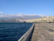
İzmir's famous Kordon
The Port of Smyrna, from an 1883 encyclopedia.
In 1415, Mehmet I re-captured İzmir for the Ottomans for the second time and with the death of the last bey of Aydın, İzmiroğlu Cüneyd Bey, in 1426 the city definitely passed under Ottoman control. İzmir's first Ottoman governor was a converted son of the Bulgarian Shishman dynasty. During the campaigns against Cüneyd, the Ottomans were assisted by the forces of the Knights Hospitaller who pressed the Sultan for the return to them of the port castle. However, the sultan refused to make this concession, despite the resulting tensions between the two camps, and he gave the Hospitallers the permission to build a castle (the present-day Bodrum Castle) in Petronium (Bodrum) instead.
In a land-bound arrangement somewhat against its nature, the city and its present-day dependencies became an Ottoman sanjak (sub-province) either inside the larger vilayet (province) of Aydın part of the eyalet of Anatolia with its capital in Kütahya or in "Cezayir" (i.e. "Islands" in reference to "the Aegean Islands". Two notable events for the city during the rest of the 15th century were a Venetian surprise raid in 1475 and the arrival of the Sephardic Jews from Spain after 1492, who later made İzmir one of their principal urban centers in Ottoman lands. İzmir could have been a rather deserted place in the 15th and 16th centuries, as indicated by the first extant Ottoman records describing the town and dating from 1528. In 1530, 304 adult males, both tax-paying and tax-exempt were on record, 42 of them Christians. There were five urban wards, one of these situated in the immediate vicinity of the port, rather active despite the town's small size and where the non-Muslim population was concentrated. By 1576, İzmir had grown to house 492 taxpayers in eight urban wards and had a number of depending villages.[16] This corresponded to a total population estimated between 3500–5000.
International port city
A distant view of the Pasaport Quay (1877) in the background, as seen from the Konak Pier (1890) at the port of İzmir.
The Konak Pier was designed by Gustave Eiffel in 1890.
İzmir's remarkable growth began starting late 16th century when cotton and other products of the region attracted French, English, Dutch and Venetian traders here. With the privileged trading conditions accorded to foreigners in 1620 (the infamous capitulations that were later to cause a serious threat and setback for the Ottoman state in its decline), İzmir set out on its way to become one of the foremost trade centers of the Empire. Foreign consulates moved in from Chios and were present in the city by the early 17th century (1619 for the French Consulate, 1621 for the British), serving as trade centers for their nations. Each consulate had its own quay and the ships under their flag would anchor there. The long campaign for the conquest of Crete (22 years between 1648–1669) also considerably enhanced İzmir's position within the Ottoman realm since the city served as a port of dispatch and supply for the troops.
The city faced a plague in 1676, an earthquake in 1688 and a great fire in 1743, but continued to grow. By the end of the 17th century, its population was estimated at around ninety thousand, the Turks forming the majority (about 60,000), while there were also 15,000 Greeks, 8,000 Armenians and 6 to 7,000 Jews, as well as a considerable segment composed of French, English, Dutch and Italian merchants.[17] In the meantime, the Ottomans had allowed İzmir's inner bay dominated by the port castle to silt up progressively (the location of the present-day Kemeraltı bazaar zone) and the port castle ceased to be of use.
The first started and the first finished railway lines within the present-day territory of Turkey took their departure from İzmir. 130 km (81 mi) İzmir-Aydın railway was started in 1856 and finished in 1867 a year later than Smyrna Cassaba Railway, itself started in 1863.[18] That the latter drew wide arc advancing first to the north-west from İzmir, through its Karşıyaka suburb contributed to the development of the northern shores as urban areas greatly. Such new developments typical of the Industrial Age and the attraction the city exercised for merchants and middlemen gradually changed the demographic structure of the city, its culture and its Ottoman character. In 1867, İzmir finally and definitely became the center of its own vilayet, still under its neighbor Aydın's name but with its administrative area covering a large part of Turkey's present-day Aegean Region.
Asansör (1907) offers panoramic views of the city.
In the late 19th century, the port was threatened by a build-up of silt in the gulf and an initiative, unique in the history of the Ottoman Empire, was undertaken in 1886 to move Gediz River's bed to its present-day northern course, instead of letting it flow into the gulf, in order to redirect the silt. The beginning of the 20th century saw the city under the genuine and cosmopolitan looks of a metropolitan center with a global fame and reach. According to Katherine Flemming, at this point Smyrna's 150,000 Greeks made up just under half of the population, outnumbering the Turks in the city two to one.[19] Alongside Greeks and Turks, there were sizeable Armenian, Jewish, and Levantine communities in the city.
Following the defeat of the Ottoman Empire in World War I, the victors had, for a time, intended to carve up large parts of Anatolia under respective zones of influence and offered the western regions of Turkey to Greece with the Treaty of Sčvres. On 15 May 1919 the Greek Army landed in Smyrna, but the Greek expedition towards central Anatolia turned into a disaster for both that country and for the local Greeks of Anatolia. By September 1922 the Greek army had been defeated and was in full retreat, the last Greek soldiers leaving Smyrna on 8 September 1922.
The Turkish Army retook possession of the city on 9 September 1922, effectively ending the Greco-Turkish War (1919-1922) in the field. Four days later, on 13 September 1922 a great fire broke out the city, lasting until 22 September. The fire completely destroyed the Greek and Armenian quarters, while the Muslim and Jewish quarters escaped damage.[20] There are different claims about who was responsible for the fire, however there were numerous eyewitness accounts of uniformed Turkish soldiers setting fire to Greek and Armenian homes and businesses.[21] Estimated Greek and Armenians deaths resulting from the fire and massacres range from 10,000[22][23] to 100,000[24][25] Approximately 50,000[26] to 400,000[27] Greek and Armenian refugees crammed the waterfront to escape from the fire and were forced to remain there under harsh conditions for nearly two weeks. The systematic evacuation of Greeks on the quay started on 24 September when the first Greek ships entered the harbor under the supervision of Allied destroyers.[28] Some 150,000 to 200,000 Greeks were evacuated in total.[23] The remaining Greeks left for Greece in 1923, as part of the population exchange between Greece and Turkey, a stipulation of the Treaty of Lausanne, which formally ended the Greco-Turkish War.
The war, and especially its events specific to Izmir, such as the fire, one of the greatest disasters the city has ever experienced, continues to influence the psyches of the two nations to this day. The Turks have claimed that the occupation was marked from its very first day by the "first bullet" fired on Greek detachments by the journalist Hasan Tahsin and the killing by bayonet coups of Colonel Fethi Bey and his unarmed soldiers in the historic casern of the city (Sarı Kışla — the Yellow Casern), for refusing to shout "Zito o Venizelos" (Long Live Venizelos). The Greeks, on the other hand, have accused the Turks of committing many atrocities against the Greek and Armenian communities in Izmir, including the lynching of the Orthodox Metropolitan Chrysostomos following their recapture of the city on 9 September 1922 and the slaughter of Armenian and Greek Christians.[29] A Turkish source on İzmir's oral history concedes that in 1922, "hat-wearers were thrown into the sea, just like, back in 1919, fez-wearers were thrown."[30] The lack of comprehensive and reliable sources from the period, combined with nationalist feelings running high on both sides, and mutual distrust between the conflicting parties, has led to each side accusing each other for decades of committing atrocities during the period. The city was, once again, gradually rebuilt after the proclamation of the Turkish Republic in 1923.
Standing on Mount Yamanlar, the tomb of Tantalus was explored by Charles Texier in 1835 and is an example of the historic traces in the region prior to the Hellenistic Age, along with those found in nearby Kemalpaşa and Mount Sipylus.
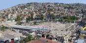
The Agora of Smyrna is well preserved, and is arranged into the Agora Open Air Museum of İzmir, although important parts buried under modern buildings are waiting to be brought to daylight. Serious consideration is also being given to uncovering the ancient theatre of Smyrna where St. Polycarp was martyred, buried under an urban zone on the slopes of Kadifekale. It was distinguishable until the 19th century, as evident by the sketchings done at the time. On top of the same hill soars an ancient castle which is one of the landmarks of İzmir.
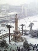
One of the more pronounced elements of İzmir's harbor is the Clock Tower, a beautiful marble tower that rests in the middle of the Konak district, standing 25 m (82 ft) in height. It was designed by Levantine French architect Raymond Charles Pčre in 1901 for the commemoration of the 25th anniversary of the ascension of Abdülhamid II to the Ottoman throne in 1876. The clock workings themselves were given as a gift by the German Kaiser Wilhelm II, a political ally of Abdülhamid II. The tower features four fountains which are placed around the base in a circular pattern, and the columns are inspired by North African themes.
The Kemeraltı bazaar zone set up by the Ottomans, combined with the Agora, rests near the slopes of Kadifekale. İzmir has had three castles historically – Kadifekale (Pagos), the portuary Ok Kalesi (Neon Kastron, St. Peter), and Sancakkale, which remained vital to İzmir's security for centuries. Sancakkale is situated in the present-day İnciraltı quarter between the Balçova and Narlıdere districts, on the southern shore of the Gulf of İzmir. It is at a key point where the strait allows entry into the innermost tip of the Gulf at its narrowest, and due to shallow waters through a large part of this strait, ships have sailed close to the castle.[38]
There are nine synagogues in İzmir, concentrated either in the traditional Jewish quarter of Karataş or in Havra Sokak (Synagogue street) in Kemeraltı, and they all bear the signature of the 19th century when they were built or re-constructed in depth on the basis of former buildings.
The İzmir Birds Paradise in Çiğli, a bird sanctuary near Karşıyaka, contains 205 species of birds. There are 63 species of domestic birds, 54 species of summer migratory birds, 43 species of winter migratory birds, and 30 species of transit birds. 56 species of birds have been breeding in the Park. İzmir Bird's Paradise which covers 80 square kilometres was registered as "The protected area for water birds and for their breeding" by the Turkish Ministry of Forestry in 1982. A large open air zoo was established in the same district of Çiğli in 2008 under the name Sasalı Park of Natural Life.
Education
The following universities were established in İzmir:
Ionian University, the first university of the city, established in 1920. It was organized by the mathematician and close friend of Albert Einstein, Constantin Carathéodory, on the instructions of the Greek government. However, it never operated due to the developments of the Greco-Turkish War.[43][44]
Ege University – Founded in 1955, Ege University is İzmir's first university to start courses. The rectorate and the campus which englobes most of the university's institutions (62 in all, with 3141 academic staff and 42,693 students for 2006/2007) are situated in the metropolitan district of Bornova.
Dokuz Eylül University – Founded in 1982 principally by the splitting off of a number of institutions from Ege, Dokuz Eylül University today equals in size to its sister university. The rectorate is in the central Alsancak neighborhood, while the campus is located in the metropolitan district of Buca, with 61 depending institutions across İzmir or in the city's districts, employing 3027 academic staff and uniting a student corpus of 43,851 for 2006/2007.
İzmir University of Economics – Founded as a private sector initiative in 2002 by the İzmir Chamber of Commerce, İzmir University of Economics is a specialized university with a campus in the metropolitan district of Balçova.
Yaşar Üniversitesi (Yaşar University) – Also founded in 2002 by Yaşar Holding, the initial building is located in the central Alsancak neighborhood, while the construction of a campus in the neighboring district of Seferihisar, outside the metropolitan zone, is under way.
University of İzmir – Founded in 2007.
Katip Çelebi University - Founded in 2010.
Şifa University - Founded in 2010.
The following universities are located nearby city of İzmir:
İzmir Institute of Technology – Founded in 1992, İzmir Institute of Technology is the city's first institute of technology, while the campus, which is Turkey's largest, is located in the nearby district of Urla.
University of Gediz – Founded in 2009, is located in the nearby district of Menemen.
There are ongoing plans to establish a sixth, and perhaps also a seventh university in İzmir. The city is also home to well-rooted high-school establishments that are renowned across Turkey, such as Izmir Anatolian Vacational High School of Commerce which was established in 1854 and the American Collegiate Institute which was established in 1878.
İzmir is also home to the third U.S. Space Camp in the world, Space Camp Turkey.
Historically, during the late 19th and early 20th centuries, the city was an educational center of the Greek world, with a total of 67 male and 4 female schools that time. The most important Greek educational institution was the Evangelical School that operated from 1733 to 1922
Connection with other cities and countries
Air
The Adnan Menderes International Airport is well served with connections to Turkish and international destinations. Its new international terminal was opened in September 2006 and the airport is set on its way for becoming one of the busiest hubs in Turkey. The city-to-airport shuttle buses are operated by the private company Havaş which run on two lines; the first connecting Karşıyaka (in the city's northern part) and the second connecting Alsancak (in the south) with the airport. Trains remain a comparatively slow alternative, while the metro line that will reach the airport is under construction. The taxis are not cheap and can cost up to fifty U.S. dollars, depending on the distance.
Bus
A recently-built large bus terminal, the Otogar in the Pınarbaşı suburb on the outskirts of the city, has intercity buses to destinations across Turkey. It is quite easy to reach the bus terminal, since bus companies' shuttle services pick up customers from each of their branch offices scattered across the city at regular intervals, free of charge.
Rail
İzmir has two historical rail terminals in the city center. Alsancak Terminal, built in 1858 and Basmane Terminal, built in 1866 are the two main railway stations of the city. The Turkish State Railways operates regional service to Ödemiş, Tire, Aydın, Söke, Nazilli and Uşak, as well as inter city service to Ankara, Afyon and Bandırma (İstanbul via İDO connection).
Alsancak Train Station (1858) in İzmir, where the first railway line in the Ottoman Empire, the İzmir–Aydın line, entered service two years earlier, in 1856.
Transportation within the city
Co-ordinated transport was introduced to İzmir in 1999, the first place in Turkey to apply the lessons of integration. A body known as UKOME gives strategic direction to the Metro, the ESHOT bus division, ferry operations, utilities and road developments. İzmir has an integrated pre-pay ticket, the Kentkart (Citycard). The card is valid on metro (subway), buses, ferries and certain other municipal facilities. The Kentkart allows use of multiple forms of transport within a 90 minute window for the price of a single fare.[47] For situations where it is necessary to use the car for travel within the city, the number of car rental companies in the various districts serving about 1000.
Bus
All major districts are covered by a dense municipal bus network under the name ESHOT. The acronym stands for "E elektrik (electricity); S su (water); H havagazı (gas); O otobüs (bus) and T troleybüs (trolleybus)." Electricity, water and gas are now supplied by separate undertakings, and Izmir's trolleybus system ceased to operate in 1992. However, the bus company has inherited the original name. ESHOT operates about 1,500 buses with a staff of 2,700. It has five garages at Karataş, Gümrük, Basmane, Yeşilyurt and Konak. A privately-owned company, İzulaş, operates 400 buses from two garages, running services under contract for ESHOT. These scheduled services are supplemented by the privately-owned minibus or dolmuş services.
Urban ferries
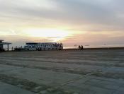
İzmir Municipality's urban ferry services in the Gulf of İzmir.
Taken over by İzmir Metropolitan Municipality since 2000 and operated within the structure of a private company (İzdeniz), İzmir's urban ferry services for passengers and vehicles are very much a part of the life of the inhabitants of the city, which is located along the deep end of a large gulf. 24 ferries shuttle between 8 quays (clockwise Bostanlı, Karşıyaka, Bayraklı, Alsancak, Pasaport, Konak, Göztepe and Üçkuyular.) Special lines to points further out in the gulf are also put in service during summer, transporting excursion or holiday makers. These services are surprisingly cheap and it is not unusual to see natives or visitors taking a ferry ride simply as a pastime.
Metro
Main article: İzmir Metro
İzmir has a subway network (rapid transit over the surface in parts) that is constantly being extended with new stations being put in service. The network "İzmir Metrosu", consisting of one line, starts from the Üçyol station in Hatay in the southern portion of the metropolitan area and runs towards northeast to end in Bornova. The line is 14.2 km (8.8 mi) long.
İzmir Metro: Stadyum (İzmir Atatürk Stadium) Station.
The stations are: 1) Üçyol, 2) Konak, 3) Çankaya, 4) Basmane, 5) Hilal, 6) Halkapınar, 7) Stadyum, 8) Sanayi, 9) Bölge, 10) Bornova, 11) Ege University, 12) Evka 3. An extension of the line between Üçyol and Üçkuyular, which aims to serve the southern portion of the city more efficiently, is currently under construction. Basic fare on the Metro is TRL 1.25 but only TRL 0.95 if the Kentkart is used. About 12% of passengers pay cash and the rest use Kentkart, 35% at reduced rate and 53% at standard rate. The Metro carries about 30 million passengers per year, and by the end of September 2005, 160 million passengers had travelled since the opening of the metro in May 2000. A more ambitious venture named İZBAN has begun involves the construction of a new 80 km (50 mi) line between the Aliağa district in the north, where an oil refinery and its port are located, and the Menderes district in the south, in order to reach and serve the Adnan Menderes International Airport. The line comprises 31 stations and the full ride between the two ends takes 86 minutes.
Commuter Rail
Main article: İZBAN
İZBAN commuter train heading towards Adnan Menderes International Airport.
İZBAN, sometimes referred to as Egeray, is a commuter rail system serving İzmir and its metropolitan area. It is the busiest commuter railway in Turkey, serving about 150,000 passengers daily.[48] İZBAN is a portmanteau of the words "İzmir" and "Banliyö".
Established in 2006 and began operations in 2010, İZBAN was formed to revive commuter rail in İzmir. Currently, İZBAN operates a 80 km (50 mi) long system, with 31 stations, consisting of two lines: the Southern Line and the Northern Line.
İZBAN A.Ş. operates the railway and is owned 50% by the Turkish State Railways and 50% by the İzmir Metropolitan Municipality. İZBAN is a part of the municipality's Egeray project.
Source
Trying to find uganda safaris primeugandasafaris ? Check out this page: primeugandasafaris
For additional local cheap plane tickets visit en. |