Daha B�y�k G�r�nt�le
Kırklareli
Coat of arms
Kırklareli is located in Turkey
Kırklareli
Coordinates: 41�44′05″N 27�13′31″ECoordinates: 41�44′05″N 27�13′31″E
Country Turkey
Province Kırklareli
Government
� Mayor Cavit �ağlayan (CHP)
� Kaymakam
Area
� District 1,528 km2 (590 sq mi)
Elevation 203 m (666 ft)
Population (2008)[1][2]
� Urban 61,880
� District 84,868
� District Density 56/km2 (140/sq mi)
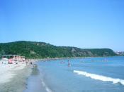
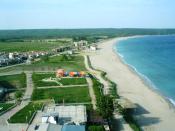
Kırklareli is the capital of Kırklareli Province in Eastern Thrace, on the European part of Turkey. The province has a coastline on the Black Sea.
Name
It is not clearly known when the city was founded, nor under what name. The Romans called it Salmydessus[citation needed] and the Byzantine Greeks called it "Forty Churches" ("Σαράντα Εκκλησιές", Saranta Ekklisi�s). In the 14th century this was translated to Turkish and called "Kırk Kilise". Following the establishment of the Turkish Republic in 1923, sanjaks became cities and on December 20, 1924, Kırk Kilise's name was changed to Kırklareli, meaning The Place of the Forties. The denomination Kırklareli was already used years before 1924, for example in the contemporary literature concerning the Balkan Wars of 1912�13. The Bulgarian name of the town is Lozengrad (Лозенград) which means Vineyard Town. (see also its other names)
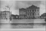
History
Ongoing archeological excavations in the city support the claim that the area was the location of one of the first organized settlements on the European continent, with artifacts from the Paleolithic and Neolithic periods.
The settlement and its surrounding areas were conquered by the Persians in 513�512 BC, during the reign of King Darius I.
In 914 during the Bulgarian invasion in Adrianopol led by Simeon I, the settlement was captured by the Bulgarians and was under Bulgarian rule until 1003 when it was lost against the Byzantines.
The Ottoman Turks took the city and its region from the Byzantines in 1363, during the reign of Sultan Murad I.
The city was damaged during the Greek War of Independence (1821�1829).
According to 1878 г. record "Ethnography of the Wilayahs Adrianopol, Monastir and Thessaloniki" Kırk Kilise was inhabited by 6 700 Bulgarians, 2 850 Greeks и 2 700 belonging to other ethnic groups.[3]
According to the official Ottoman census of 1906�1907 (published in "The Ottoman Population 1830�1914: Demographic and Social Characteristics" by Kemal H. Karpat), the ethnic-religious breakdown in the Sanjak of Kırk Kilise was: 22,022 Muslims; 14,154 Greek Orthodox; 1,599 Bulgarian Orthodox; and 789 Jews.[4]
During the Balkan Wars (1912�1913) Kırk Kilise was occupied by Bulgaria, and then by Greece in the aftermath of World War I (1914�1918) resulting in mass imigration of Bulgarian population. Following the Turkish War of Independence (1919�1922) the city was retaken by the Turks on November 10, 1922. According to the 1923 population exchange agreement between Greece and Turkey, the Greeks of the city were exchanged for the Muslims (Turks, Pomaks, Karadjaovalides and Albanians) living in Greece. Most of the inhabitants of the city are Turks who formerly lived in Thessaloniki until the First Balkan War of 1912. The Treaty of Lausanne (1923) which defines Turkey's western border in Thrace also defined the western boundaries of the Kırklareli Province.
The Megleno-Romanians of Kırklareli
In 1923 most of the 3700 inhabitants of Notia, the only Muslim village of the Megleno-Romanians in northern Greece, settled in the Edirne area (mainly in Kırklareli) and became known as Karadjovalides[5] after the Turkish name of Moglena.[6]
The number of these megleno-vlach families settled in Kırklareli were more than 110, while those settled in small villages around were 400: in total nearly 2000 Megleno-Romanians. Actually they number only 500, concentrated in Kirklareli and culturally assimilated to the Turks (most of them speak mainly the Turkish language, but are still bilingual at home.)
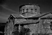
Cultural Assets
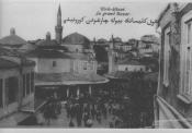
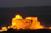
The Hızır Bey Mosque and K�lliye were built by the Ottoman Turks in 1383.
The Ottoman era Arasta adjacent to the Hızır Bey Mosque and K�lliye.
Hızır Bey K�lliye: This k�lliye (religious complex) consists of the Hızır Bey Mosque, Hızır Bey Bath and Arasta (Bazaar.)
Hızır Bey Mosque: Located at the center of the city, it was built on a square plan by K�se Mihalzade Hızır Bey in 1383. Built of cut stone and having one minaret, it was restored by Yusuf Pasha of Aydost in 1824. Still used today, the final praying place and garden walls of the mosque were built afterwards.
Hızır Bey Bath: Also located at the center of the city and built adjacent to Bath and Arasta by K�se Mihalzade Hızır Bey in 1383. There are two entrances, one each for women and men, which are also called the "Paired Baths". According to an inscription in the women's bath, Hacı H�seyin Ağa restored it between 1683 and 1704. Still used today, the outer walls are regular and built from coarse sandstone. It's a Turkish Bath in the traditional Ottoman architecture style.
Arasta (Bedesten): Built adjacent to the Hızır Bey Bath in a "T" form, it has arch-type walls. The upper cover is a vault 15 m long. There were 12 shops inside formed by three beams. It was restored in 1704.
Kırklareli Jewish Quarter: A historic neighborhood.
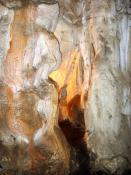
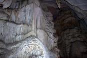
Dupnisa Cave: Kırklareli Province is also host to the only cave that is open to tourists in Thrace, the Dupnisa Cave near the village of Sarpdere, which is believed to have formed circa 4 million years ago. The Dupnisa Cave was used for Dionysian Rituals (Sparagmos) in ancient times. Even the name of Dionysus is associated with Mount Nisa right above the cave of Dupnisa; as, according to ancient Greek mythology, Dionysus "discovered wine while playing at Mount Nisa."[7] The Bulgarian name of Kırklareli, Lozengrad (Лозенград) which means Vineyard Town may also have its origins in this ancient Greek myth.
Source |