Daha Büyük Görüntüle
Gümüşhane
— District —
Location of Gümüşhane within Turkey.
Gümüşhane is located in Turkey
Gümüşhane
Location of Gümüşhane
Coordinates: 40°28′N 39°29′E
Country Turkey
Region Black Sea
Province Gümüşhane
Government
• Mayor Mustafa Canlı (MHP)
Area
• District 1,789 km2 (691 sq mi)
Elevation 1,227 m (4,026 ft)
Population (2010)[1]
• Density 26.08/km2 (67.5/sq mi)
• Urban 28,620
Time zone EET (UTC+2)
• Summer (DST) EEST (UTC+3)
Postal code 29xxx
Area code(s) 406
Licence plate 29
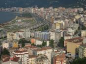
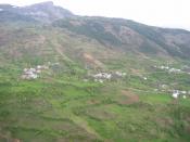
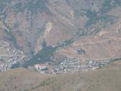
Gümüşhane (pronounced [ɡyˈmyʃaːˌne]) is a city and the capital district of Gümüşhane Province in the Black Sea region of Turkey. The city lies along the Harşit River, at an elevation of 5,000 feet (1,500 m), about 40 miles (65 km) southwest of Trabzon. According to the 2010 census, population of Gümüşhane urban center is 28,620.[1][2] The district covers an area of 1,789 km2 (691 sq mi),[3] and the town lies at an elevation of 1,227 m (4,026 ft).
Name
The name literally means "silver house". It is composed of Turkish: gümüş (silver) and the Persian: خانه hane=khane (House). The name is derived from the silver mines nearby. In Byzantine times the area which the city belongs was called Chaldia. After the Greek Revivalism in the area in 1850's the city was called in Greek Argyrňpolis (silver town), by the intellectuals of the city. The ancient Greek name of the city was Θήρα (Thera) meaning, gate or doorway. It was also known Canca during first half of 16th century.
Geography
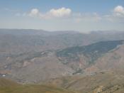
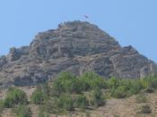
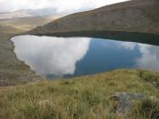
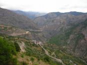
Gümüşhane is surrounded by high mountains, Zigana-Trabzon Mountains to the north, Çimen Mountains to the south, Giresun Mountains to the west and Pulur, Soğanlı Mountains to the east. Trekking is popular sport is at these mountains. The Zigana Mountain has a ski center on it and it is a well known touristic place for winter sports. Abdal Musa Peak (3331 m.) is the highest peak within it. The main trees in the forests are Scotch pine and fir, and there are many animals and birds in the area. There are many lakes such as Karanlık Göl, Beş Göller, Artebel Gölü, Kara Göller which are at the peak of Gavurdağı Mountain, and are preserved as natural parks. All these mountains compose 56% of the area of Gümüşhane province.
Climate
Gümüşhane has a humid continental climate with cold and snowy winters and hot and humid summers. In the height of summer; July and August, temperatures at midday usually surpass 30°C, summer nights tend to become very cool due to the high elevation of Gümüşhane, and in winter temperatures usually plummet to -10°C and even go as low as -30°C occasionally
Main sights
Old Gümüşhane city, 1910s Ottoman era postcard
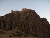
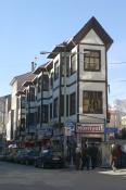
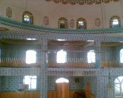
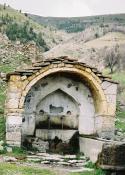
Gümüşhane has a rich historical background so there are many historical places, mosques, churches, castles. Ancient city of Satala in the modern village of Sadak was the most important military camp of the ancient Roman Empire in the east. This place was ruled by the Hittites, Assyrians, Urartu, Persians, Pontic Greeks, Romans, and Byzantines. Today, rests of the Sadak village is protected by the Ministry of Culture and Tourism. In addition, Süleymaniye Mosque is in the previous Gümüşhane settlement and it was commissioned by the Ottoman sultan Süleyman the Magnificent. Küçük Mosque and Çit Village Mosque are some of other popular mosques in the city. Besides, there are numerous churches within Gümüşhane. Santa Çakallı, Santa Terzili, Kalur Rock, Samamoni, and Theodor Churches are some examples of historical churches in Gümüşhane.[5][6]
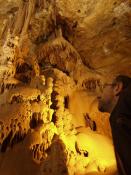
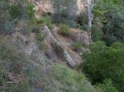
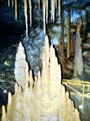
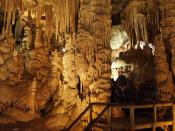
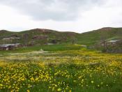
There are numerous large and small caves due to the geological structure of Gümüşhane. Karaca Cave is the most popular in Gümüşhane due to its some specific characteristics. The total length of the cave is 150 meters. It is a fossil cave and is located between Torul and Gümüşhane. The waters leaking from the crack system cutting each other. Formation of interesting stalactites, stalagmites, columns, and travertine pools are some features of Karaca Cave. Gümüşhane is also popular with plateaus hidden between the forests. Zigana, Taşköprü, Artabel, Şiran and Kalis plateaus are some of them and summer festivals are organized every year.
Cuisine
Many native tourists join these festivals to entertain and also to shop some regional items or food. Pestil and köme are renowned desserts of Gümüşhane, they are made from mulberry, honey, nut, walnut and milk. In addition to köme and pestil, rosehips, apples, and walnuts are some common natural food and by means of them many different desserts are made in Gümüşhane. It has a rich food culture; mantı, lemis, erişte, borani, kuymak, evelek dolması and siron are some of well known food in Gümüşhane.[7]
Pontic Greek influence
Question book-new.svg This section does not cite any references or sources. (April 2011)
Gümüşhane is a town located 80 km south of Trabzon in Pontus (Turkey), and hometown of the province of Chaldia. The city was established around 700 BC as the settlement of Thyra (Greek: Θύρα) by Ionian Greeks who first discovered silver in the region. Its Greek name stems from two Greek words (argyro, meaning silver and polis = city). Other names used to describe the town were Argyropolis (Αργυρόπολις), Γκιμισχανά, and Κιουμουσχανά.
Around 840 AD, Argyroupolis was included in the new Roman (Byzantine) province of Chaldia (Χαλδία). It was also ruled by Umayyads, Emirate of Mengujekids, Empire of Trebizond, Akkoyunlu and Safavids. During Ottoman years, the sanjak of Argyroupolis fell under the administration successively Rum Province, Erzurum Province and Trabzon (Trapezunta in Greek) Province, and was divided into four kazas: Argyroupolis (Gümüşhane), Torul (capital city Ardassa), Şiran (Cheriana), and Kelkit (Keltik). The sanjak in which Argyroupoli was situated at some stage comprised 37 mines of argentiferous lead and six copper mines. There is no evidence that these mines were in use during Byzantine times.
The first residents of Argyroupolis settled in the region just after the fall of Trebizond (1461) and the town soon became a home for miners. Sultan Murad ΙΙΙ (1574–1595) appears to have granted extra privileges to the chief miners and the town prospered and soon became a centre of Hellenism. At the time, it had 60,000 residents. Its trade was increasing and the whole province of Chaldia was on the rise. Another example of its development was that they minted coins with the name Kioumous-hane on them. Another example was the settlement of chief mining families there such as the Sarasites, the Karatsades, the Stavracoglous, the Kalimachidises, the Grigorantons and others. There were also more jewellery shops opening, as well as more hagiography and other arts in the region.
The rise in wealth and abundance soon brought positive changes to the communities. From the beginning of the 18th century new schools were opening, and from 1723 the Frontistirion (Greek Tuition Centre) of Argyroupolis was in full operation. The tuition centre became an educational institution and spiritual centre of the region. In 1650 the diocese was elevated to archdiocese status, and hundreds of churches and temples were built. New mines rich in minerals were discovered in Ak-dag Maden and Argoni, which resulted in a large exodus of miners from Argyroupolis to the new mines. The drop in population was followed by the Russo-Turkish War of 1829–30, and the majority of its inhabitants fled to Southern Russia, Nicomedea, Mesopotamia and other mining regions; from Tiflis to as far as Ak-Dag and the Taurus. During those years tension between the Greek and Muslim population was also growing due to the Greek Revolution and the revelations of the Stavriotes who practiced two religions (Christianity in private), but came forward and publicly declared their Orthodoxy.[8]
During those confusing and troubling times many people became benefactors of Argyroupolis, such as the Sarasite family and the influential teacher Georgios Kyriakidis. Kyriakidis identified the need to extract large sums of money from the churches of Saint George, Saint Theodore, Τίμιου Σταυρού and Παναγίας for the educational needs of the town. Sale of church property as well as donations and consecrations resulted in the erection of a new school at the Frontistirion of Argyroupolis, a school which was to operate until the Exchange (1923). The Frontistirion comprised a three-grade high school, a seven-grade primary school including scholarship classes, and a six-grade girl's school, as well as a carpet-making technical school.
Another public building was the library, the Educational Society Kyriakidis, as well as the Metropolis of Chaldia. The Argyroupolitans therefore are very much regarded as having some of the best resources in education, due mainly to their economic rise as a result of mining.[9]
After the turmoil and ethnic strife (1914–1923), few ethnic Pontic Greeks managed to flee to Greece. Those that did settled in the Macedonia region of Northern Greece. A small group which settled in Naousa brought precious items with them from their churches in town, as well as items from the library of the Frontistirion, including rare manuscripts and books. This collection is still in use today and is considered[by whom?] a prized asset of Naousa.
The town was occupied by the Russian army on July 20, 1916, but the Russians withdrew on February 15, 1918, after the fall of the czar. After the exchange (1923) no Orthodox remained in the region.
Source |